


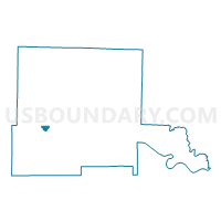
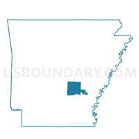
38 Voting District, Jefferson County, Arkansas
About
Outline

Summary
| Unique Area Identifier | 526910 |
| Name | 38 Voting District |
| County | Jefferson County |
| State | Arkansas |
| Area (square miles) | 1.19 |
| Land Area (square miles) | 1.19 |
| Water Area (square miles) | 0.00 |
| % of Land Area | 100.00 |
| % of Water Area | 0.00 |
| Latitude of the Internal Point | 34.22184550 |
| Longtitude of the Internal Point | -92.09742650 |
Maps

Graphs
Select a template below for downloading or customizing gragh for 38 Voting District, Jefferson County, Arkansas


Neighbors
Neighoring Voting District (by Name) Neighboring Voting District on the Map
- 23 Voting District, Jefferson County, AR
- 65 Voting District, Jefferson County, AR
- P70 Voting District, Jefferson County, AR
- P81 Voting District, Jefferson County, AR
Top 10 Neighboring County Subdivision (by Population) Neighboring County Subdivision on the Map
- Vaugine township, Jefferson County, AR (49,211)
- Washington township, Jefferson County, AR (9,380)
- Niven township, Jefferson County, AR (1,682)